
When I was starting bushwalking one of my treasured possessions was a small guidebook – The Gundungura Guide. It was produced after a lot of research by members of SURC – Sydney University Rover Crew. This guidebook covered a large part of the Southern Blue Mountains – in particular the area between Kanangra Walls and the Wollondilly River including Yerranderie and the Kowmung River.
At first I used this guide for its notes on the Kanangra Canyons and walking routes to the Kowmung River. Later, I appreciated it more for its background material – in particular the notes on geology and geomorphology. The principal author of the guide was Athol Abrahams, who later went on to a career as a distinguished academic geographer in the United States.
The material in the guide was based on research done by SURC members throughout the 1960’s and printed in 1970. A few years later it had sold out and now has become a collectors item amongst bushwalkers. As well as the guidebook, SURC published two maps. The first was a small sketch maps of Nellies Glen -that covered a gap between Myles Dunphy’s Gangerang – Wild Dog Mountains Sketch Map and the well known area of Katoomba. This was drawn by Geoff Ford. The second map was a group effort and much larger in scope and format. This was the Gundungura Map. It covered a lot of the area that was later covered in text form in the Gundungura Guidebook and also filled a then gap in a series of sketch maps that Myles Dunphy had compiled of the Blue Mountains.
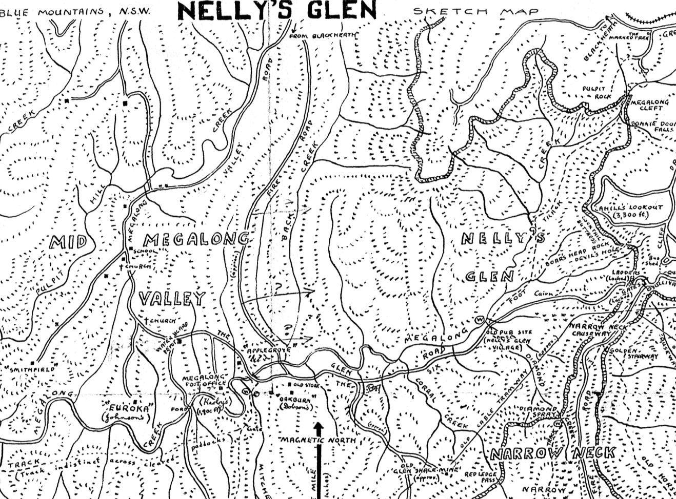
Part of the Nelly’s Glen Sketch Map
Recently, the originator of the Gundungura Project, Dr Geoff Ford has made a lot of this material available in the public domain. I have been happy to host copies on my website for people to download. So far you can download scanned copy (pdf) of the Guidebook and a copy of the Nellies Glen Sketch Map as well as background notes. Go to this page for the downloads.
Thanks to Dr Geoff Ford for making this material available and also for all the members of SURC who undertook the research that was involved in the project. This included many bushwalks in the region. Geoff Ford also informs me that in the 1960’s SURC had a lot of notes on their trips that were written up in large logbooks. These seem to have vanished when SURC was dissolved later in the 1970’s. If there are any old SURC members or their descendants who know anything about the present location of these logbooks then please get in touch and I will pass on the information.
Fantastic resource, thanks for heads up!
Therein, I found the route descriptions, e.g. between Kowmung and Kanangra Road that I’ve been walking few years back choosing circuitous variants because they looked easiest (but not necessarily shortest) on the map and by eyeballing the terrain. Had I know the notes from that booklet, I would have walked into the passes head on!
But looking ahead, I’m planning to visit Blue Breaks and this booklet describes well the eastern part. I need some clarification though about naming of places on Tonali Range before I’m confident about using this guide. In particular, the name “Bull Island Peak”. This guide says that you go from Green Wattle Gap, scramble over “Bull Island” and then continue along “Razor Blade” of Vengence Peninsula and descend to the junction of Green Wattle and Bull |Island Creeks. I can see an unnamed peak ~half km east of Green Wattle Gap. But the topo map shows “Bull Island Peak” actually located a 1 km to the SW, separated by a deep saddle between headwaters of Tonali River and Bull Island Peak.
I assume the naming have changed recently. Am I right that the unnamed peak I refer to above, is what they call “Bull Island”? Then, the true “Bull Island Peak” according to topo map, how is it called? I can see the reference to a mystery “Alchemy Mountain” against the back-drop of “man-made lake” (Warragamba), would it be it?
Planning my trip, I’m thinking of traversing Axhead & Vengence and dropping to the junction of Green Wattle and Bull Island Creeks. Then, the Lacy Tableland Wall, at a head just 1km E of there, seems to be broken up. Does this break let me up to the top? Then go S until I hit an easy looking spur jutting W onto Bull Island Gap. Then over true “Bull Island Peak” and reverse the Axhead traverse, and back home. I think such trip including approaches from Katoomba via White Dog Ridge, can be done in 4 days. Maybe I need 5 if I’m excited and wander a bit further SE to explore Tonali Tableland before going back. Are my plans reasonable?
Many of the SURC names for features are not official and are not on the topographic maps. Have a look at – http://www.david-noble.net/BlueMts/BlueBreaks/Blue_Breaks.html and the linked page on Axehead Mountain to see which names apply to which features.