The Blue Breaks
"The Blue Breaks is suggested as the place name for the area bounded by Butchers Creek, the Coxs River, Wollondilly River and Tonalli River. It consists of a dissected sandstone plateau in the form of cliff-walled ranges and canyons and characteristic sandstone gaps or breaks. The main valleys are Lacys, Green Wattle and Butchers or Black Hollow Creek"
- Myles J Dunphy, Gangerang Sketch Map
Note - All text and images are the copyright of David Noble. © David
Noble 1998. Revised 2009
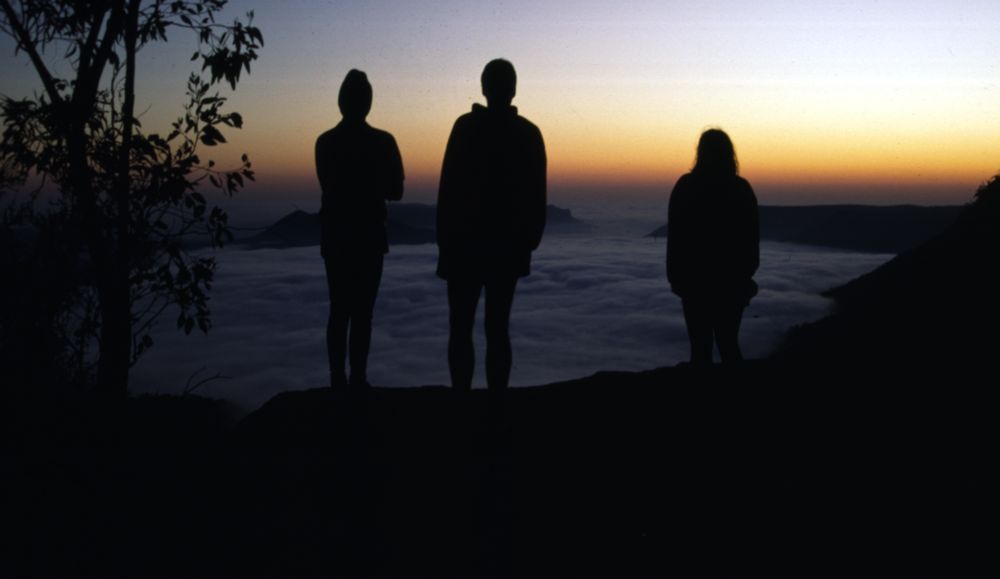
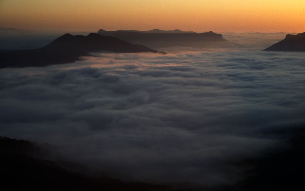
Above - Dawn - Axehead Mountain
The Blue Breaks form part of the Kanangra Wilderness area of the Greater Blue Mountains. It is one of my favourite destinations for extended walks - because of its relatively close proximity to Sydney and the superb scenery it offers. It is best suited to trips of 5 - 8 days in length. This makes it ideal for walks during the cooler months.
It is by virtue of its ruggedness, remoteness and the inundation of the Burragorang Valley that the Blue Breaks has largely retained its wilderness character. As a wilderness it shares many features in common with areas in the Northern Blue Mountains such as the Wollangambe Wilderness. Namely - scrub, difficult to negotiate clifflines, suitability for extended trips and arduous navigation and route finding. However, despite the lack of "true" canyons it does boast some fine high level traverses - both challenging to walk and rewarding in that they offer some of the best views in the Blue Mountains. Indeed, some bushwalkers have stated that the traverse of the Axehead Range is one of the "best" ridgewalks in the state. The full traverse of the Bimlow Tableland is as challenging as most ridgewalks in the Northern Blue Mountains such as those in the rugged Baal Bone area and the views are better. In much of the Blue Breaks can be found massive, continuous, sandstone clifflines (some of the highest in the Blue Mountains).
At present the total number of visitors who penetrate beyond the
hinterland of this region is fairly small.
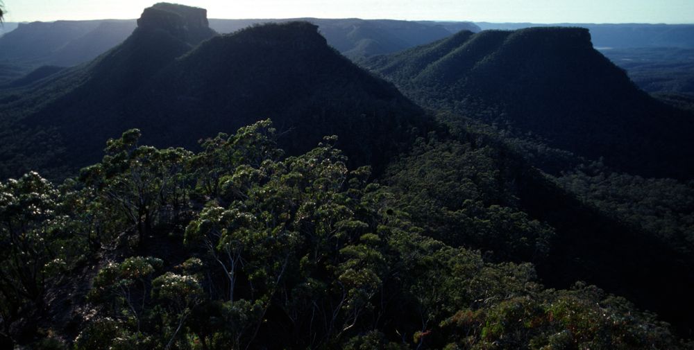
Above - Vengeance Penimsula, Bull Island and Bull Island Peak from
Axehead Mountain
Conservation.
The Blue Breaks is still in its primitive state. Lake Burragorang has covered over the farms and scars made by man on the northern and eastern side. The roads that farmers pushed down Lacys and green Wattle Creeks are now very faint and will soon be difficult to discern. During the late 70’s the status of the land was increased from waterboard catchment area to include national park stature. It was also recognised as being an important part of the core of the Kanangra Wilderness Area.
One would think that with the Blue Breaks being now included in The Blue Mountains National Park, its position would now be secure from degradation. This is only partly true. Some developments around its perimeter have festered like cankerous sores. Some of these developments have been centred around a resurgence of activity at Yerranderie. Another problem area has been Byrnes Gap.
Sydney Water has also contributed to deteriorating the wilderness
quality by widening the road along Scotts Main Range. This road which
effectively cuts the Kanangra Wilderness in two. It should never have
been
built.

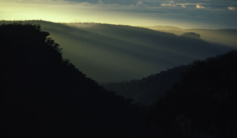
Above - View south from Broken Rock Range
Access.
It is now possible to drive to Yerranderie by 2 WD vehicle. This is not recommended however as it is often better to walk to the Blue Breaks from places like Kanangra Walls as part of a circuit trip or to visit on your way on a long walk say from Mittagong to Katoomba.
|
From Batsh Camp |
half to one days walk to Yerranderie |
|
From Mittagong or Picton |
about two days walk via the scenic Nattai Valley |
|
From Kanangra Walls |
one to one and a half days walk to Byrnes Gap or two days walk to Yerranderie for a slow party |
|
From Katoomba |
one and a half days walk to the northern Blue Breaks |
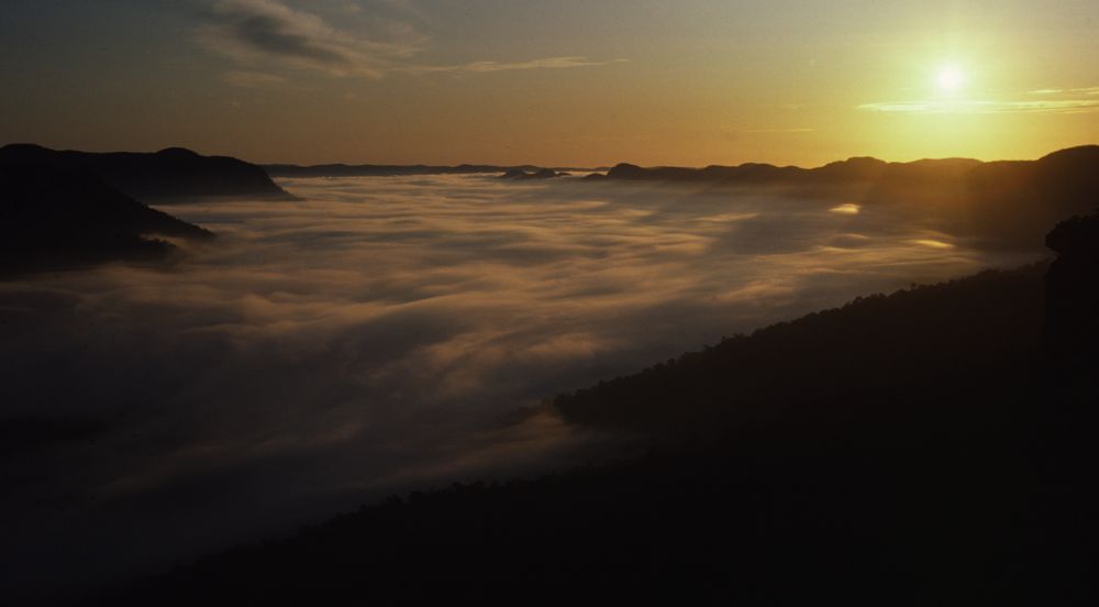
Above - Dawn light - Lacys Tableland from Axehead Mountain
Description.
The Broken Rock Range. The cliff lined part of the Broken Rock Range presents an excellent and challenging walk with superb views. It is easy to reach the range from the north and traverse all the way to the southern end and descend the steep "cliffs of dirt" below an easy pass through the clifflines. Just north of Mt Broken Rock lies another obvious pass to Butchers Creek. The passes off Catt and Shoobridge Heads are steep and dangerous and only suitable for experienced scramblers. Water can often be found in rock traps in the small non perennial creeks on the tops but carry water in dry conditions. High camps can be made almost anywhere and in some places small camp caves offer protection.
Bimlow, Lacys and Tonalli Tablelands. These provide a contiguous elevated area but the three areas differ in features and attractiveness for the walker. Lacys Tableland has fine views on its rim but much of the walking on top is away from this in scungy forest. Tonalli Tableland offers remoteness, fairly open walking (except near the clifflines) and some interesting scrambling and routefinding (to get down off them). Bimlow Tableland offers challenging routefinding, some prickly scrub, some superb high camp sites and views generally better than those of the Broken Rock Range (because Broken Rock Range is included in the view!). Like on Broken Rock Range, water can often be found on the tops in the small creeks.
Above - Morning mist in Green Wattle Creek Valley.
There are many passes and routes onto these tablelands. Some are obvious from an inspection of the map such as Lacys Gap - which appears to be a old bridle trail. An obvious steep scrambling pass lies down Terni Head and provides convenient access to and from the Bull Island. A few other places along the rim also offer steep routes. Bimlow Tableland has very few passes from it to Green Wattle Creek but many passes on its eastern side for those not afraid to tangle with Lawyer Vines. There are also several passes high up in the headwaters of both branches of Lacys Creek and the small Barkers Canyon. The massive ramparts of Doyle’s Prospect overlooking the junction of the two Lacys Creek branches offer no passes known to the author.
The Axehead Range. This range is named not from its shape but from the fact that during the mining days of Yerranderie, many of the trees of the Tonalli valley were felled by axe to provide pitprops. It provides an excellent high level "skyline" traverse along what is almost a knifedge ridge. There is some fairly straightforward scrambling and routefinding.
Above - Dawn, on Axehead Mt.
Views are perpetually outstanding. Although a traverse from near Byrnes Gap to the start of Green Wattle Creek can be comfortably completed in a day it is very worthwhile to camp high up on the range. Water only occurs after rain at a few places in small rockpools.
Bull Island Peak (or Alchemy Mt) stands remote from the ridge chain but is part of the Axehead group. It can be reached from the Axehead Range or from the Tonalli Valley via the Chinaman Bluffs (scramble up the cliffs on the western side). The best way onto or off this mountain is via the "Razor Blade" - a true knifedge ridge that heads off to the northeast towards Lacys Tableland.
Butchers (or Black Hollow) Creek lies along the western
border of the Blue Breaks. It starts near Byrnes Gap and flows north
into Lake Burragorang. For much of its length it offers easy pleasant
walking. The best parts are near the Grog Shop just north of Axehead
Mtn and the last part just before it enters the Lake. Highlights are
the excellent campsites at its junction with its attractive tributary,
Butlers Creek (well worth visiting in its own right) and the "Bowling
Green" campsite at the Rocky Creek junction.
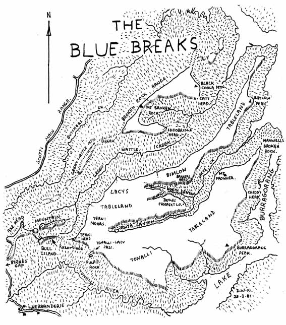
Green Wattle Creek is wild and remote and offers varying walking along its length. it starts at a fine Blue Gum forest type campsite (surely one of the best in the Blue Mountains) where Bull Island and Butchers Shop Creeks join. The first few kilometres are very pleasant with grassy banks and large Blue Gums. Near Green Wattle Break it flows through an alluring small canyon reminiscent of the Hellgate Canyon on Harrys (Jenolan) River. Below the canyon the walking is less pleasant until near Fritzs Creek junction where enormous flats flanked by the massive Bimlow Walls offer pleasant campsites. Fritzs Creek offers an interesting route onto the Broken Rock Range.
Lacys Creek is the most remote of the major Blue Breaks Creeks. Lower down it offers attractive grassy flats and tall timber. Higher up its to branches offer different walking. The North Canyon is a steep boulder filled gorge whilst the South Canyon for much of its length contains a Blue Gum forest that rival that of the Grose River. Walking is slowed somewhat by ferns and vines on the banks.

Above - Shoobridge Head, Broken Rock Range - late afternoon from Bimlow Tablelands.
Suggested Walks.
1. Batsh Camp, Yerranderie (via Colong Gap), Yerranderie Peak (sidetrip), Tonalli River, Chinaman Bluffs, Bull Island Peak, Lacys Tableland, Bimlow Tableland, Green Wattle Creek, Broken Rock Range, Green Wattle Mountain, Green Wattle Creek, Axehead Mountain, Batsh Camp. 6 days. Medium hard.
2. Kanangra Walls, Bullhead Range, Kowmung River, Bulga Range, Byrnes Gap, Axehead Mountain, Green Wattle Creek, Green Wattle Break, Broken Rock Range, Butchers Creek, Kowmung River, Gingra Range, Kanangra Walls. 6 days. Medium hard
3. Katoomba, Narrow Neck, White Dog, Coxs River, Mt Cookem, Butchers Creek, Broken Rock Range, Catt Head, Green Wattle Creek, Lacys Tableland, Lacys Creek - North Canyon, Lacys Creek, Tonalli Tableland, Tonalli Peak, Tonalli River, Wollondilly River, Belloon Pass, Nattai River, Starlights Trail, Mittagong. 7 - 8 days. Medium hard.
4. Kanangra Walls. East Christies Creek, Kowmung River, Bulga Range, Byrnes Gap, Axehead Mountain, Green Wattle Creek, Bull Island Creek, The Razorblade, Bull Island Peak, Yerranderie, Church Creek Caves, Kowmung River, Bullhead Range, Kanangra Walls. 5 - 7 days. Medium.
5. Kanangra Walls, Bullhead Range, Kowmung River, Bulga Range, Byrnes Gap, Axehead Mountain, Bull Island Peak, the Razorblade, Lacys Tableland, Lacys Creek - South Canyon, Bimlow Tableland, Green Wattle Creek, Broken Rock Range, Butchers Creek, Kowmung River, Gingra Range, Kanangra Walls. 6 - 7 days. Medium hard
Continue to the Axehead Range
Continue to Lacys Tableland, Bimlow Tableland and
Lacys Creek
Continue to Bimlow Tableland
Continue to Broken Rock Range
Return to Greater Blue Mountains Menu
Return to david-noble.net