
A long weekend is a great time for bushwalking. The extra day allows you to go further than you normally can on a two day weekend – and that is a great bonus. The long weekend in June, with typically cool weather, is a good time for camping high and enjoying the sunrise and sunsets.
Over the past few years many of the trips I have gone on on the June Long Weekend have been either to the Red Rocks or the Blue Rocks. These two places are quite different and lie on opposite sides on the southern rim of the Capertee Valley.

The Red Rocks lie on the eastern side of the valley and are named after the major sandstone cliffs that often glow red in the setting sun. The Blue Rocks lie to the west and is the name of a small limestone outcrop low in the valley – well below the sandstone layers that dominate the cliffs. The Blue Rocks, being limestone, do harbour some limestone caves – but these are fairly small in extent.

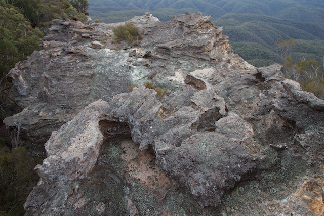
Both the Red Rocks and the Blue Rocks feature some amazing pagoda rock formations and the tops of these pagodas are exquisitely decorated by intricate and complex ironstone formations of great beauty.

This year on the long weekend, I was joined by Rob, for a walk to McLeans Pass, Point Cameron, Pantoneys Crown, Baal Bone Point and Baal Bone Gap. This was almost the reverse of a walk a lot of us did two years ago. That walk was was very good and I was keen to repeat it.

Of interest are the pagodas on the Wolgan/Capertee divide between McLeans Pass and Mt Jamison. On the way – the divide is cut by a large chasm, which turns out to be very easy to cross. Once past this obstacle, you climb onto an open rocky area that is littered with contorted boulders. It is as if a pagoda has exploded and scattered debris all over the tops. To the north lies a pagoda maze known as the “Lost City”. Another interesting area lies on the way to Point Cameron. It is a set of domes. These are rounded pagodas.


Point Cameron was where we camped on the first night. It is a great place with splendid views looking into the Capertee Valley. To the north lies the mesa of Pantoneys Crown. This impressive table like mountain is named after William Pantoney, one of the members of a party of Europeans to visit the Capertee Valley in 1821. Interestingly enough, it was the site of a proposed nudist colony in the 1970’s. The idea being that the isolated top would be a good place for nudists to wander around well away from prying eyes. However, this proposal did not eventuate, the nudists went to the nearby Rowans Hole and the Crown was gazetted as a nature reserve. It is now part of the Gardens of Stone National Park.


On the second day of the walk – we descended off Point Cameron, via an easy pass and crossed the valley to climb Pantoneys Crown. There are passes near the south and north of the plateau and a traverse of the Crown is a popular trip. Neither pass could be described as easy. Both involve some scrambling – and there is some exposure involved. However, in scrambling terms the passes are not too hard and the views from the top make them worth trying.
Also the top is a great place to camp. It is not far to climb onto pagodas and then admire the views. At the highest point, hidden under a rock is a biscuit tin containing not one but two logbooks. Both seem to have been currently used.


Our return part of the walk took us to Baal Bone Point – another impressive and spectacular place. The saddle between Pantoneys Crown and Baal Bone point is open and provides easy walking. There is a very convenient pass up onto the point a short way around on the east side. From there it is again easy and scenic walking to Baal Bone Gap. At the Gap – we followed fire trails back to the car which was back on the Great Dividing Range.
More photos of the walk are on my main website here.


Great photos Dave! I love this area but only recently ie last Friday found out where the water is on the top of Pantoney’s. Last Wednesday (2/11/11) Dave Dash and Brian Fox located it the water, took a sample for a water quality researcher, and Michael Keats emailed me the grid reference. I’ve never camped up on Pantoneys but have traversed it a couple of times on day walks.
Hi Allan/Dave,
I am heading out there in about a month with a small group and was wondering if you could send through the grid reference for the water supply on the crown Thx heaps
The only water I have found on the crown has been in rock pools at the southern end. This was after rain. I have carried water up from the pressure reducing station at Baal Bone Gap. I don’t think it would be hard to find where water is on the crown – in one of the small canyons that flow off the crown to the west. They look very likely to have permanent water, but possibly a bit of trouble to get into to get the water for your camp.
Hi Dave, this area looks like a wonderful weekend hike. Great photos too! Do you have map references for your traverse? I’d really love to do this with a couple of friends soon… Thanks
I do have a gps log of an earlier version of the walk (back in 2009) – see –
http://www.david-noble.net/bushwalking/BlueRocksJune09/BlueRocksMap.html
and
http://www.david-noble.net/bushwalking/BlueRocksJune09/GPSPage.html