Note - All text and images are the copyright of David Noble. No text
or images can be reproduced in any form without permission from David Noble. © David Noble 1998. Revised slightly 2009.
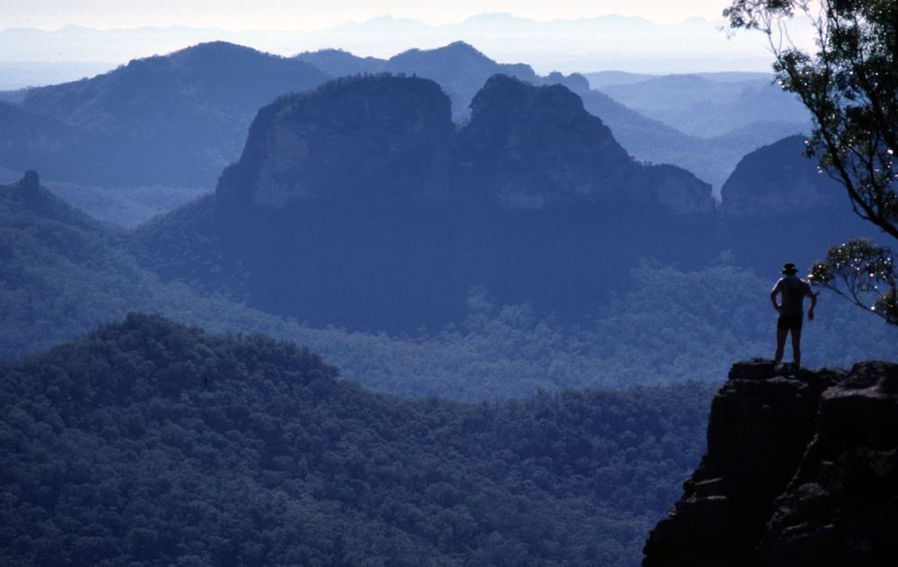
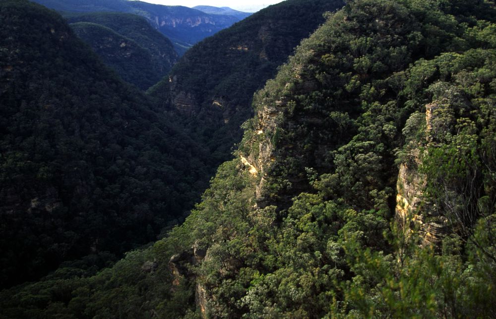
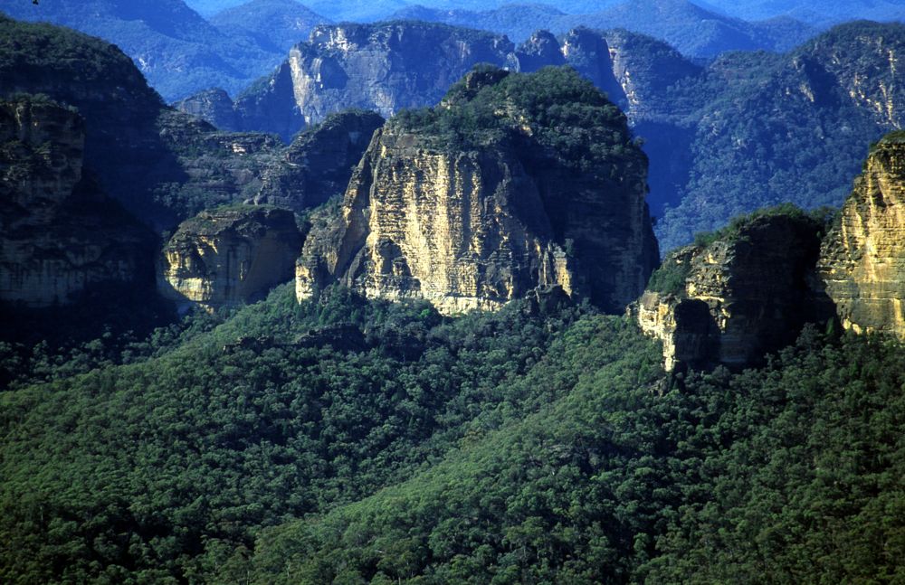
Above - Wedding Cake Mountain (Yodellers Range) from Minaret Peak
The Widden Valley lies in the extreme north of the Greater Northern Blue Mountains. Whilst not wilderness itself the valley and its environs offers some of the most spectacular scenery to be found anywhere within NSW. The escarpment and plateaux above the valley are within the Wollemi National Park. To the west of the valley lies the Bylong Labyrinth - a virtually untouched landscape of deep cliff lined gorges, canyons and complex pagoda ridges. To the south and east lies the core of the Colo - Hunter Wilderness - the largest remaining wilderness in the state.
The easiest way into the Valley is from the Putty Road, then to Denman, then via the Sandy Hollow and Bylong Roads. As one drives up the Valley the full panorama of peaks and cliffs appears. Alternative access via Rylstone to Nullo Mountain, the Nullo Road eventually becomes a firetrail and enters the valley via Myrtle Creek.
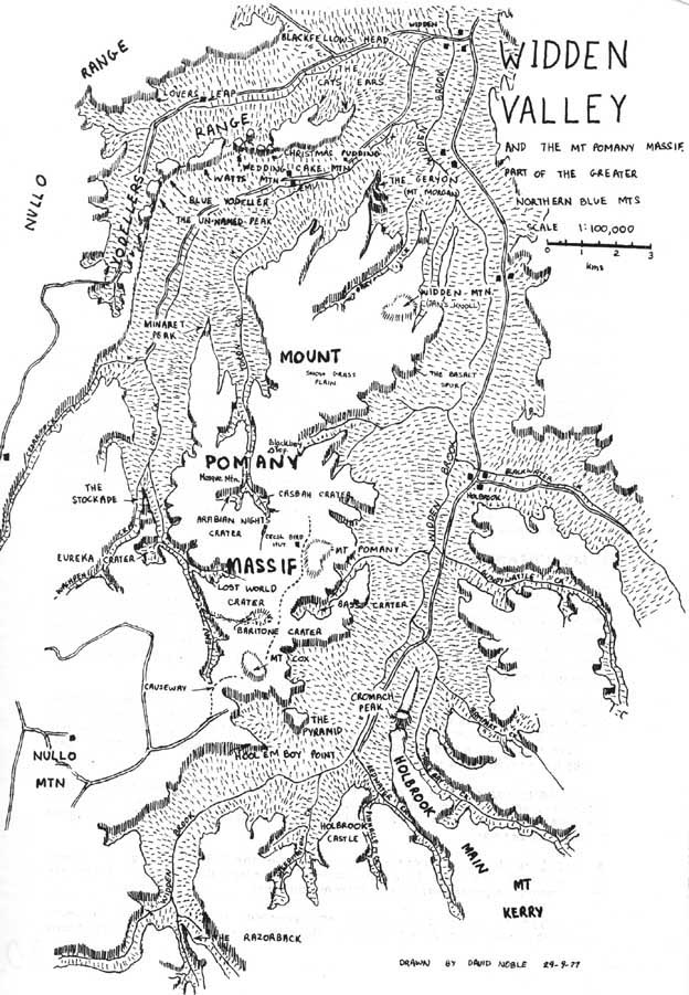
Maps
Note: Most of the valley floor is private land. Consequently permission from farmers should be sought by persons wishing to travel through the farms in the upper part of the valley (in particular Holbrook, Emu Ck and Myrtle Ck farms). The 1:25,000 maps, with their cadastral details are useful in showing road reserves and the extent of privately owned land.
Water is scarce on the floor of the valley in the major creeks which often flow underground. Upstream, where the creeks flow across rock bands their are usually pools in even the driest weather. The best places to camp are in the valleys above the level of the farms. Indeed, the upper part of Widden Brook just after it leaves the narrow and steep section offers superb campsites on grassy flats.
1 Widden Valley Proper
The Razorback. This is the ridge separating Razorback and Coricudgy Creeks. Viewed from the ridges off the Great Dividing Range to the south it seems a steep knife-edge. There may be some difficulty traversing the whole ridge as it is cut by a number of chasms, one of which contains an old bridle track (cattle, apparently, were taken up Widden Brook into Coricudgy Ck and through the chasm into Razorback Ck before being taken over the divide into the Cudgegong).
Holbrook Castle. The exact location of Holbrook Castle is not known to the author. Lands department maps mark it as being on the end of the spur between Coricudgy and Sheepstation Creeks but Bill Filson's sketchmap marks it as being between Sheepstation and Pinnacle Creeks. Both are surrounded by giant ramparts that could suggest a castle but presumably, Bill Filson talked with the Harris family of Holbrook Stud about which one was the Castle (and the Lands Department have other local names marking the wrong feature - eg Wedding Cake Mtn in the Yodellers Range). The "castle" closer to Coricudgy Creek, although being flanked by a smaller clifflines is actually quite a difficult scramble to reach the top. It is also connected to the Mt Coricudgy - Mt Kerry ridge system by a ridge system of "labyrinthine complexity"3 that has repulsed several strong parties.
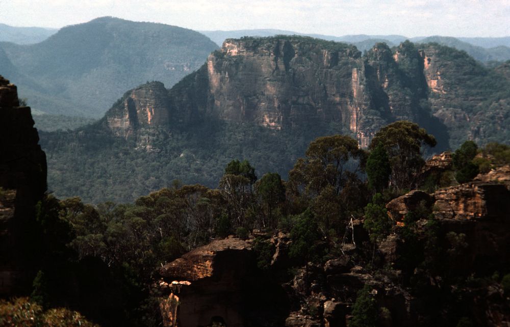
View from Hool Em Boy Point showing the Pyramid (left middle) and the conical Cromach Peak behind it to the right.
Cromach Peak is the most dominating feature of the ridge leading north west from Mt Kerry. It is named "Holbrook Main" on Filson's Map. The name "Cromach" only appears on the 1:50,000 RASC map. It is an impressive conical shaped peak of rotten rock. The traverse to Mt Kerry requires some tricky rock scrambling and routefinding.
The Pyramid is really a Zigurat shaped prominence that is separated from the main cliffline. It looks very worthwhile to climb.
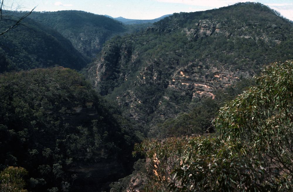
Creeks. The upper section of Widden Brook which flows through a spectacular narrow gorge can be entered from the Nullo Mt road as it crests the mountain. The upper part of the Brook is very pretty and features a large stand of Eucalyptus St. Johnii and numerous orchids. A good return route is from Razorback Creek along the Great Dividing Range, which offers fine views. It is also worth climbing up through the cliffline onto a vantage point overlooking the junction of Widden and Razorback Ck -as well as a fine view an extraordinary pinnacle can be seen. Razorback Ck (Goodwater Ck?) is very open and pleasant offering easy walking. Coricudgy Creek is somewhat slower. Pinnacle Creek is a fine canyon and needs rope. Redwater Creek offers a route down from Mt Kerry and is quite pretty. Blackwater Creek flows in an impressive gorge and has several small canyon tributaries. Downstream, above the creek, in a low saddle leading to Gundywattle Ck is a large natural arch. The land of lower Blackwater Ck is owned by the NP&WS.
Above - Upper Widden Brook
Above - Widden Brook - further down
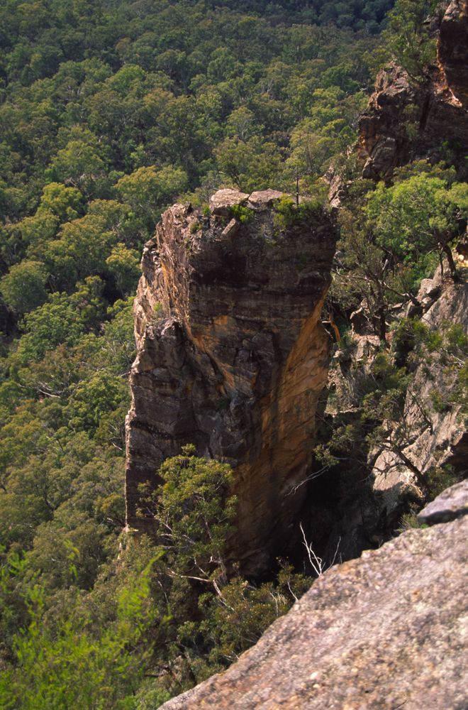
Above - The pinnacle between Razorback Creek and Widden Brook
2. Mt Pomany Massif.
This is joined onto Nullo Mountain by a narrow causeway. A bridle track goes from Nullo Mt out past Mt Pomany. Water is scarce on the Massif. A spring flowing into a cattletrough just north of the site of the Cecil Byrd hut (it has been recently burnt down) is handy and reliable. Mts Cox and Pomany are basalt. From the clear part of Pomany there are fine views. There are many passes onto the Massif. They are obvious from below but are hard to pick from above and the cliff information on all the maps is very poor.
Craters. Most of the volcanic necks have open grassy sections but some also have large areas of stinging nettles (eg ArabianNights and Casbah Craters) When water is available they make excellent campsites. Bass Crater has a bridle track leading to it.
Minaret Peak offers excellent views particularly of the Yodellers Range. It is fairly easy to reach the peak from the Mosque Mountain direction but there are complications in getting off it or on it from Emu Creek.
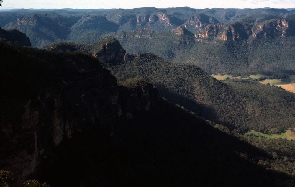
Above - Mt Morgan from the Yodellers Range
Mt Morgan combines spectacularity and grandeur to form one of the most outstanding features in the whole valley. The western wall is a monstrous sandstone slab inclined at about 80 degrees. The traverse over the tops is tricky requiring an abseil to negotiate one of the chasms south of the main peak. The main peak is itself fairly easy to climb (it seems to have been first climbed in l935 by Edith Field - the mountain was known then as Mt Morgan according to a scrap of paper found on top). Also, the main peak (2nd peak) and the 4th peak as you go south have massive rock buttresses on their eastern sides that would offer great scrambling potential.
3 The Yodellers
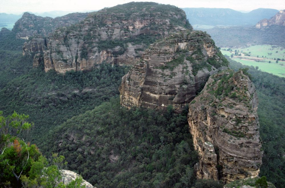
The Yodellers Range is undoubtedly the most spectacular the most outstanding sandstone ridge system in the state. The Yodellers Traverse (over about 4 short weekend stages) is unequaled for quality rock scrambling. This is over very poor rock and is often very exposed. Progress is often slow due to routefinding but the views are breathtaking. Details of the traverse have been described elsewhere6. Water is not found on the skyline but can often be found in the creeks to the northwest by dropping down a hundred metres or so. Two ropes and a 2 litre water container are useful. Despite the difficulties, there are really only a few places where ropes are really needed for a traverse that does not deviate far from the skyline.
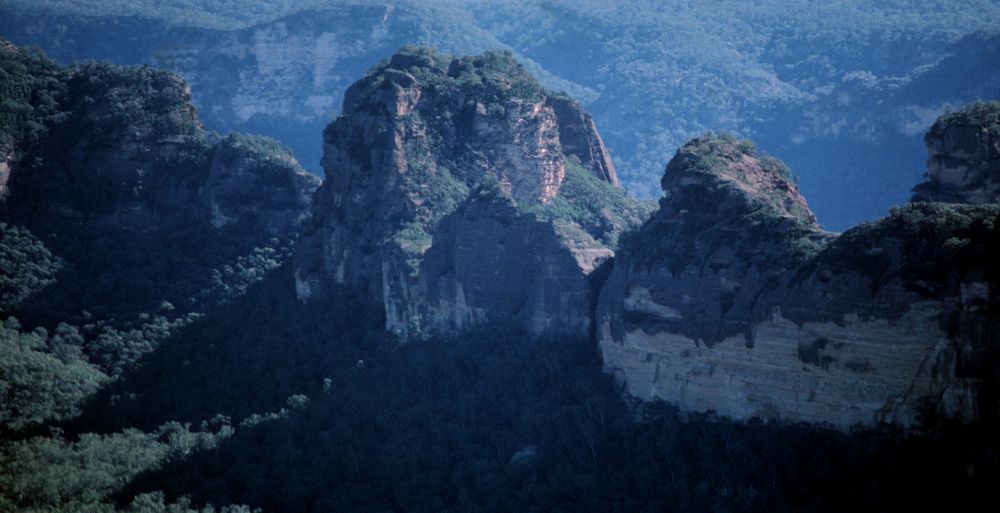
Above - Wedding Cake Mountain, Yodellers Range, from Mt Morgan.
Above - Wedding Cake Mountain and
Mt Morgan from the Lovers Leap Range
Lovers Leap to Blackfellows Head. This is an excellent high
level scrambling traverse. Views are outstanding.
Cedar Creek and Washpen Creek are fine rainforest gorges and would appear to be the only places in the whole of the Northern Blue Mts where stinging trees are found. Cedar creek does indeed have many cedar trees.
4 SUBW in the Widden Valley
SUBW probably did not visit the valley very often prior to 1976. This was probably due to the valley's remoteness and the lack of detailed maps. The first good map of the area (the Pomany 1:50,000 RASC sheet) was published in 1974. Even a cursory glance at this map reveals many features that would entice bushwalkers to explore the area. The first SUBW trip that I am familiar with took place probably during l975 when the author accompanied by Col Mathers and Meg Shirlow repeated Ted Daniel's (NPA) trip into upper Widden Brook. The first major exploratory trip was on the Anzac long weekend of 1976 and was from Nullo Mountain to Mt Pomany. It was from Mt Pomany that the rugged nature of the Yodellers Range was first noted. The party, consisting of Chris Cosgrove Keith Maxwell, Rose Adams and the author then descended into Casbah and Arabian Nights Craters and then traversed to Minaret Peak which they could not descend from. In early May a party set out from Nullo Mtn for the first stage of the Yodellers traverse. The full traverse was completed over 4 weekend stages that concluded in April 1978. The walkers that were on most of these trips included Chris Cosgrove, Keith Maxwell and the author (SUBW) and Tom Williams, Gordon Thompson and Steve Moon (SBC).
Meanwhile, during the August break, 1976 Chris Cosgrove. R.A.X. Bradstock, Ian Hickson and others started a Widden to Glen Davis trip by climbing Watts Mtn in the Yodellers Range and then climbing Mt Pomany via Turon Ck. They then dropped into Bass Crater and then into Widden Valley. Next, they traversed Cromach Peak on their way to Mt Kerry.
Other major trips took place during June 1977 when the Stockade was traversed by Tom Williams, Chris Cosgrove, Keith Maxwell, Bob Sault and the author. A late start from Emu Creek caused the party to be benighted on top and become overdue. During early August 1977, the Mt Morgan was traversed by the same party, one memorable feature being a "high camp" on the 4th summit. During the August holidays, the same party minus Keith and plus Adrian Teague completed a major exploratory traverse of the nearby Bylong Labyrinth over 5 days7.
Above - View from wedding Cake Mountain in the Yodellers Range - Looking towards the Christmas Pudding. The closest peak is climbed via a chimney next to a rib on the front left and then up easy slabs on the right face. The chasm separating this peak from the Christmas Pudding is a difficult problem.
5 Related Reading
1. Williams, Tom. Up North. The Yodellers. In Kameruka Vol 15 No I (Sept 77).
2. Brown, Les. Mt Coricudgy - Widden Brook- Mt Wilworral. In Kameruka Vol 4 No 3 (1965).
3. Daniels. Ted. Walks report. National parks Assn journal, June 1973.
4. Cosgrove, C and Ritson, D. Northern Blue Mountains Wilderness Park. NSW Federation of Bushwalking Clubs, 1977.
5. Noble, D and Burton, B. The Colo Wilderness, Honi Soit 25/7/78 (includes cover photo of Yodellers Range).
6. Williams, T and Noble, D. First Traverse of the Yodellers, Australian Outdoors, March, 1981
7. Noble. D. A Walk Through the Bylong Labyrinth, Kameruka Vol 16, No 1. (March 1978).
Continue to Widden Valley Area - Page 2
Continue to the Yodellers Range
Return to Greater Blue Mountains
Menu
Return to david-noble.net