
Bungleboori Creek is one of the great creeks of the Northern Blue Mountains. It flows through the heart of the Wollangambe Wilderness – part of Blue Mountains National Park.
It is a creek I have been visiting for many years. I think my first trip to Bungleboori Creek was in 1974. In those days the map we used was the Wallerawang 1:63,360 sheet – the classic one inch to the mile map. On that map, Bungleboori Creek was marked by name. It started near Cockatoo Hill and flowed east. Part way along, it was joined by its south branch. This was marked on that map as “Bungleboori Creek 9 mile branch”. Above the junction, bushwalkers, and later canyoners, always referred to the two branches of the creek as “Bungleboori Creek North Branch” and “Bungleboori Creek South Branch”. These are logical names as both branches are roughly the same size in terms of flow and the size of the gorges they have cut.
The 1:25,ooo maps were produced in 1975 (Rock Hill) and 1976 (Wollangambe) and those sheets claim they have approved place names. On those maps, above the junction, the south branch is labelled “Bungleboori Creek” and the north branch is not labelled. Why? Probably because the path of the north branch lies right along the divide between the two maps. It crosses from map to map and may not have looked that significant to cartographers. One tiny tributary, a very minor side creek high in the headwaters was labelled as “Dingo Creek”. This name was not added further downstream from where that tiny creek joined with other creeks to form the north branch.
The lack of a label on the north branch did not matter to bushwalkers and canyoners. They simply still called it “Bungleboori Creek North Branch” (or the North Branch of Bungleboori Creek).
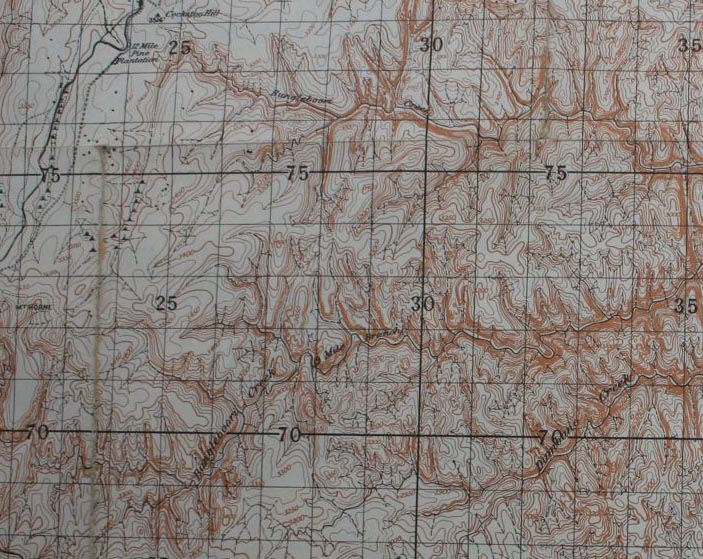
Part of the Wallerawang 1:63,360 Map
A later map, the Blue Mountains Burragorang Tourist Map (Central Mapping Authority – 6th edition 1979) had the Wollangambe Wilderness included on it. The earlier Myles Dunphy version of the map ended at the Bell Road. It had some curious new nomenclature for the Wollangambe Wilderness. Ridges were named – Brakevan Ridge, Shay Ridge, Boiler Ridge, Railmotor Ridge and Beyer Ridge. These names were associated with railways – perhaps a reference to the former railway to Newnes (which used Shay locomotives). These names had no historic significance with the area itself – only perhaps its hinterland. Also, on that map – Bungleboori Creek North Branch had been relabelled as “Caboose Creek”. I wonder why an American term was used here rather than the Australian term “Guardsvan”? This map did however have printed on it “Place names are not necessarily geographical names under the Geographical Names Act 1966”.
Another map produced around the same time was the RASC Wallerawang 1:100,000 map. It had the north branch marked as “Bungleboori Creek” and the south branch marked as “Nine Mile Creek”.
So what do newer maps have marked? It looks like an error has been made, probably by a junior clerk at the government office responsible for mapping (the LPI). They have assumed that the name “Dingo Creek” applies to the much larger creek downstream. This name is shown on current digital editions. The trouble is that when a wrong name is marked on a modern map – that people new to the area tend to use that name. This is a shame when that name “Dingo Creek” is clearly wrong and also quite confusing in this case.
It is also worth knowing a bit more about the background of mapping this area. See here for a discussion.
Interesting post Dave, thanks for sharing. I’ll have to do some research of my own on the topic when I get the chance, but it would be an interesting one to address with the Geographic Names Board. I’m currently talking with them regarding another name place issue.
I found your blog on this because I’ve just noticed that Google maps marks Bungleboori as ‘Nine Mile Creek’. I was curious where the name came from – thanks for the explanation.
I wonder is it possible to put google maps on the right track?
The old name for that branch was “Bungleboori Creek Nine Mile Branch”. A later map just marked it as “Nine Mile Branch”. The nine miles comes from the pine plantations in the headwaters. There was one at 9 miles, one at 12 miles (from Newnes Junction?) etc. These are marked on the Wallerawang 1″ to the mile sheet. I think the sensible and logical names should be Bungleboori Creek South Branch and Bungleboori Creek North Branch. Renaming the north branch as “Dingo Creek” is like renaming Parramatta River as Toongabie Creek.
You’d have to ask Brian Fox and Michael Keats why they thought it a good idea to apply to the Geographical Names Board to have Bungleboori North Branch renamed Dingo Creek, in which they were successful. Caboose Creek would be a Wilf Hilder name, and it appears on a 1972 sketch map of the area by Chris Cosgrove, so to suddenly have it renamed Dingo Creek is brushing aside historic bushwalker useage. I was of a mind to write a protest about this to the GNB, but since I never got a reply to my earlier protest over the mishandling of the renaming of Boorong Crags http://www.bushwalkingnsw.org.au/bushwalking/wp-content/uploads/2014/07/2009-BWSpring.pdf I haven’t followed up on it.
Another interesting name change in the area, though it looks like it happened a while ago is that of Annie Rowan and Rocky Creek.
From a few of the other maps I’ve seen, such as the one below, Annie Rowan Creek is shown where Rocky Creek now lies!
http://nla.gov.au/nla.obj-234121033/view
Also, Runnings Stream Creek seems to be pointing up what we call Coorongooba…