by David Noble (September 2004)
Return to Menu Page
These persepectives are offered from the point of view of a bushwalker from Sydney, Australia after a first visit to the Sierra Nevada Mountains of California USA. I have extensive bushwalking experience in the Blue Mountains west of Sydney, and have walked in the following mountain regions - Tasmania - Central and SW wilderness areas, New Zealand - Southern Alps, Patagonia and Central Africa (Mt Kenya and Ruwenzori Mts)
The Sierra Nevada mountains are about 400 miles long and 80 miles wide. As such they are certainly one of the world's great hiking destinations. As well as many major trails, the Sierras also provide great scope for off trail walking. The countryside below the timberline is relatively scrub free. The terrain, although steep and rugged, is not too bad compared to other mounain ranges for starightforward passes and routefinding.
The rock is mainly granite and darker granodiorite. Most of the peaks have extensive areas of talus. One feature of areas like Yosemite and Tuolomne are large granite domes. The highest peaks are near Mt Whitney in the south of the range and in the Palisades.
There are two long distance walking trails - the John Muir Trail which goes from Yosemite to Mt Whitney (about 215 miles) and the Pacific Crest Trail (all the way from Canada to Mexico) - which coincides with the JMT for most of the common section of the Sierras. There are numerous other trails. There is enormous scope for off trail walking. A lot of local hikers do walk off trail - as the summit registers show, but you don't tend to see them as there are so many routes. On the JMT - the number of other hikers I would see each day would vary in number from 12 to 30 or so.
It does not rain in July or August. Well almost. Sometimes there is a short afternoon thunderstorm. This means you only need to carry a light parka and a light tent or fly. The flowers are probably better in July - but the bugs are too! Better to see the flowers in their glory and avoid the mosquitoes by camping high. In summer it gets dark around 9:30 pm and light at 5 am.
I carried a Macpac Minaret tent - the one I normally use in NZ and Tasmania and take ski-touring. This was overkill in the Sierra Nevadas. The mosquitto netting was appreciated however. I wore my usual Dunlop Volley shoes - but they suffered on the first trip - the soles splitting under the ball of the foot on both shoes. This was worrying but not catastrophic. I have never encountered this problem with volleys before. Perhaps it is due to the rough nature of the granite or the grittyness of the sand (the trails are sandy and rocky). I had a second pair of volleys for the second hike - and they did not suffer the same fate - perhaps due to changing my walking style somewhat. On the third trip I carried both pair of volleys - but ended up wearing the first pair the whole way. They lasted OK. The volleys were fine for the trail walking and for walking on granite slabs and talus. They were not the best for walking on snow.
I carried a small gas (butane/propane) stove - and carried two cylinders on each section of the trip that I went solo on. I ended up using about one and half of these per section. This includes boiling three cups of water for breakfast and three or so pots of water each evening. Because of bears - you do not cook inside your tent annex in this range - so I also carried a windshield for the stove so I could cook outside. I carried a thermal top, a lightweight fleece jumper and a heavier fleece and also fleece pants (which were mosquito proof). I also carried a fleece hat and fleece gloves (which I only used on Mt Whitney summit). Just as important is a long sleeve shirt, sunglasses and hat. I walked in shorts. On the trail there is not much shade. Mosquito repellant (DEET) is essential.
Yes - lots of pine trees. On the first hike - I carried the Lonely Planet guide - and did learn to tell some species - lodgepole, whitebark, jeffrey pines, but later forgot which ones had three needles and which had five etc. The aspen near Mono Creek provided a pleasant change.
In July - the wildflowers are absolutely amazing! These provide one of the best reasons to go and see this range.
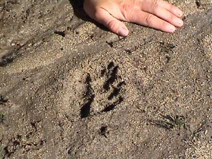
On the hikes I saw one bear, lots of deer, marmots, squirrels and chipmunks. I did not see any Bighorn Sheep - but due to the dedication of people like Lizzy's uncle, John Wehausen this species may survive. See here and here for more details. On Gabbot Pass, Lizzy and myself came across some prints. We thought they may have been from a Wolverine.
I carried a 35mm SLR and shot 50ASA fujichrome velvia on all walks. I also carried a very compact digital camera (a Pentax Optio S) - which was used to take all the photos on these web pages. I carried one spare battery for the digital camera - and this was just enough. On the second hike - I also carried a Sony digital video camera - with two small batteries. I ended up shooting about 135 minutes of video which I have edited to a 45 minute movie on a DVD.
Most of my still photography was carried out at dusk and dawn when the light was good. During the day I did take a few "snapshots". Unfortunately there was not very much of the dramatic stormy lighting that you can get in other mountain ranges. I also missed the mists of the Tasmanian and New Zealand mountains. But the dawn and dusk light was good and very atmospheric.
Yes - some people are taken for a ride! Coming from Australia I am not used to seeing horses and mules on the tracks. On the first hike I encountered some horse riders near Yosemite and near Sunrise. We encountered quite a few horses and mules on the second trip (in the trail up to Duck Lake, Fish Creek, near Silver Pass, Mono Creek and on the Pine Creek Trail). On the third hike - I only saw two ladies with two mules near Glen Pass. These animals make the trails smelly and dusty.
See this site for an explanation and pictures of ducks. It was interesting to see that some of the early visitors (1930's) in the Mt Gabb summit register had mentioned duckbusting on their way up. I find myself agreeing with the opinion of Secor quoted in the website above.
Unfortunately much of the water in the Sierras is polluted by giardia and other micro-organisms. Steve Roper in his book (see below) has a good discussion of the problem and if it is real. I did carry a small bottle of iodine crystals and saturated solution that I had borrowed from Doug and Lizzy. To treat water you could add a capful or two into a litre of water. I found I did not use it a real lot (I did not like the iodine taint). At breakfast and dinner- I had hot drinks so my water was boiled. During the day - I would often get water from either springs or snowmelt or from creeks, pools or soaks at high altitudes that would be unlikely to be contaiminated. I was never sick. I carried some wine cask bladders for use as water containers. These were good as it allowed me to camp a fair way away from water sources (and away from mosquitoes if needed). During the day I carried a 1 litre nalgene bottle and filled it when I got to good sources.
Most of my hiking was spent above 10,000' - and I did feel the lack of oxygen. But starting from Yosemite Valley (4,000') meant my climbing was more gradual. But climbing to the passes was always hard work - and it is best to go as lightweight as possible. After the first part of the hike - I did leave some gear with people in Mammoth who could take it back to Doug and Lizzy's place.
I used maps from US Geological Survey and Tom Harrison Maps.
The USGS maps were 1:24,000 in scale and good for details for the off trail walking. They are called "quadrangles". They are fairly expensive (US$ 6 - 9) and do not cover a large area of country (7.5 minutes). I only carried a few of these maps for important sections were I wanted more detail
The Tom Harrison maps are 1:63,360 (inch to the mile) shaded relief topographic maps and printed on waterproof plastic. I used 5 of these maps (Yosemite, Mammoth, Mono, Kings Canyon and Whitney) as well as a more detailed (1:24,000) Yosemite map. These maps are very clear, cover a large area, fold easily and have mile distances on the trails marked on them. These maps cost about US$9 each. These Tom Harrison maps reminded me a fair bit of the 1:50,000 maps of New Zealand.
Here are some terms you may encounter -
|
USA |
Australia |
|
hike |
bushwalk |
|
trail |
track |
|
timberline |
treeline |
|
switchback |
zig zag |
|
duck |
cairn |
|
resupply |
buy more tucker |
|
off trail |
walk cross country or off track |
|
tarp |
fly |
|
bugs |
mosquitoes etc |
|
summit register |
logbook |
Return to Menu Page